Natural Significance
 The Tenasserim WEFCOM corridor, the first high priority of Thailand biodiversityconservation corridor initiative lies on the Tenasserim range in western Thailand. It links between 19 protected areas in the Western Forest Complex (WEFCOM) and 4 protected areas in the Kaeng Krachan Forest Complex (KKFC) and in the west of both complexes border forested areas in Myanmar. It is situated in the crossroads of 4 biogeographical zones; Indo-Chinese, Sino-Malayan, Indo-Burmese, and Eastern Indian and 4 floristic provinces; Indo-Burmese (Himalayan), Indo-Malaysian, Annamatic, and Andamanese. These overlaying zones have contributed a unique assemblage of species, and have provided high biodiversity and natural resources to these regions. Moreover, the complexes are also sources of 6 of 25 watersheds of the different rivers in Thailand.
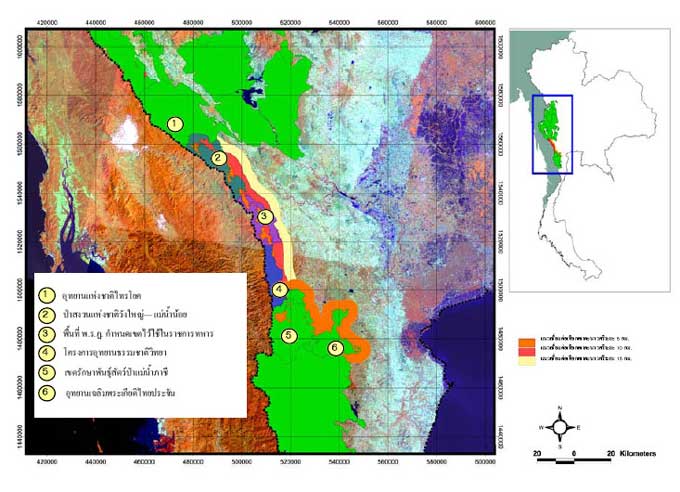
The so-called Tenasserim WEFCOM corridor zone is located in the Tenasserim Range, along the international boundary between the Kingdom of Thailand and the Union of Myanmar. It links two forest complexes the Western Forest Complex (WEFCOM), an assemblage of 19 protected areas, and the Kaeng Krachan Forest Complex (KKFC), an assemblage of 3 protected areas. The gap between the two forest complexes is approximately 75km long. The Corridor as delineated is a 10km wide area from the border inward, and spanning two provinces, i.e. Kanchanaburi (60 %) in the north and Ratchaburi (40 %) in the south.
Because the Tenasserim Range is in the economic corridors being developed across subregion, development activities can adversely affect the functions of crucial ecosystems by breaking them into small fragments.
Therefore, the proposed 'biodiversity corridor' aims to establish sustainable management regimes for restoring ecological connectivity and integrity, by maintaining / improving the habitat conditions and the biodiversity of the wildlands and associated ecosystems present in the corridor, which ultimately will facilitate the wildlife movements across.
WCS Challenges in the Tenasserim Corridor
WCS conducted research along the Tenasserim Corridor under the 2 Phases project:
Greater Mekong Subregion Core Environment Program (CEP) and Biodiversity Conservation Corridor Initiative (BCI)
>> Wildlife and Its Habitat Assessment in the Corridor Zone under the BCI Pilot Site in the Tenasserim WEFCOM Thailand and
>> Land-use and Forest Type Classification for the CEP-BCI Tenasserim WEFCOM Corridor using Remote Sensing, GIS Analysis, and Rapid Ground-truthing Techniques
As part of a cooperative agreement with the Department of National Park, Wildlife, and Plant Conservation (DNP), the Wildlife Conservation Society (WCS) has engaged itself actively in the preservation and restoration of the biological diversity of the Tenasserim Corridor. The main project, that WCS has been running as the Implementation Agency (October 2006-March 2009),
was called "Wildlife and Its Habitat Assessment in the Corridor Zone under the BCI Pilot Site in the Tenasserim WEFCOM Thailand". Its objectives were to determine wildlife and habitat status along the corridor zone and adjacent core areas using landscape species approach and to identify linear corridors or stepping stones to be targeted in a future conservation and rehabilitation program. The different activities undertaken through this project fall into the following five broad categories:
(1) rapid assessment on status of target landscape species and wildlife habitat in the corridor and adjacent core areas,
(2) design and set-up of long-term wildlife & threats monitoring system,
(3) identification of critical corridor links and/or stepping stones to facilitate movement of selected key landscape species,
(4) training and capacity building of local people and PAs staff to self-conduct the monitoring,
(5) wildlife and forest conservation awareness throughout the corridor zone.
As tangible outputs of these activities, data and maps of the distribution of selected landscape species were to be generated, as well as key linear corridor/stepping stones in the landscape, to be identified. Those key datasets are to be used during future landuse planning for the conservation of habitats and wildlife diversity, and the restoration of the ecosystem connectivity between the two complexes.
In particular, for the latter, to be able to clearly identify and further delineate these linear corridors/stepping stones, it is essential to have a clear picture of the forest condition at present in the corridor zone. That requires an up-to-date, accurate and documented dataset of the current landuse/cover of the Corridor. However, as the WCS field biologists were out in the field collecting wildlife data, they found that the information on vegetation types and land-use along the 70-km long corridor was rather outdated and inaccurate, which would create a major problem in planning (as well as it was for designing the wildlife surveys).
As a result of this evidence, WCS Thailand proposed, as an addition to the main project, to conduct a sub-project named "Land-use and Forest Type Classification for the CEP-BCI Tenasserim WEFCOM Corridor using Remote Sensing, GIS Analysis, and Rapid Ground-truthing Techniques". The aim was to create a new landuse/cover dataset based on the interpretation of higher resolution and more recent imageries, using an innovative image classification approach, and validated through a sound field-based ground-truthing work, with a special focus on trying to separate 'undisturbed forest' from degraded / regrowth stages as well as to differentiate cultivated crops.
Objectives
The two main objectives were: to produce an updated, finer and validated landuse/cover dataset of the Corridor, through image analysis, ground-truthing and accuracy assessment; to identify potential linear corridors/stepping stones in the Corridor, through a corridordesign analysis.
Area of Interest
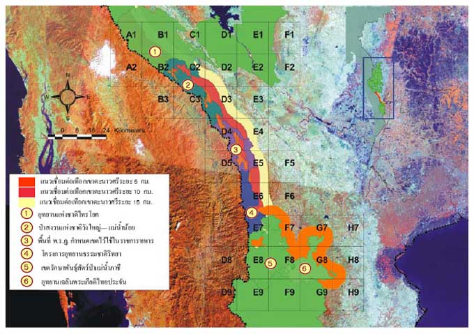
This study mainly focuses on 6 main areas. There are 1) Sai Yok National Park (SINP), the lowest protected areas in WEFCOM, 2) Maenam Pachee Wildlife Sanctuary (MPWS), and 3) Chalerm Prakiat Thai Prachan National parks (PCNP); the upper part of KKFC, 4) Wang Yai-Maenam Noi National Reserved Forest, 5) area under supervision of Royal Thai Army (RTA), and 6) the Natural History Park initiated by the Princess Sirindhorn (NHP).
Conclusion
There are positive outputs of this project to be highlighted. Thanks to this initiative, GMS-CEP and DNP is now custodian of a comprehensive collection of recent, decent resolution imageries for the whole Corridor. This is a precious asset which needs to be maintained and, should the circumstances arise, supplemented. If any additional datasets exist, such as a higher resolution DEM or a set of high resolution aerial photos, that should be incorporated for future landscape analysis. The first step in building a sound field-based ground-truth dataset has begun; should the exercise continues, it should be expanded. Through this exercise, we have been exposed to the techniques, joys and troubles, tricks and tips of a full remote-sensing based? landuse/cover classification, followed by a preliminary corridor-design analysis. Several new approaches have been introduced and tested. In terms of landuse/cover dataset production, the use of midresolution Aster images, the image enhancement (bringing the mid-IR band into the classification), the use of Decision Tree algorithm, and the use of pan-sharpening, are all innovative things not commonly seen in similar exercises elsewhere. In terms of biodiversity corridor design, the exploration and integration of two modeling approaches (Maximum Entropy method and Wildlife Linkage Design) together, were pioneering.
With all this said and reported, and at the time of handing over results and deliverables to GMSCEP and DNP, it is worthwhile stressing that, should the suggestion below calling for an extension of this exercise be followed, there is here an opportunity and a potential to foster further the in-house capacity of DNP to run this enterprise, always a valuable commodity.
Project Publication
Restoring TENASSERIM CORRIDOR For Living Connectivity (English Version)
 Contents
- Why Tenasserim Corridor?
- WCS Assignments
- Landscape Species playing key role
- Field survey design
- Forest and landuse in the landscape
- Abundance of wildlife in Tenasserim Corridor
- Modeling landscape species distributions
- Human utilization and threats
- Guidance for restoration of key clusters
- Importance of long-term monitoring
- Key interventions for future hope